Top 20 Largest Countries in the World by Area (2026)
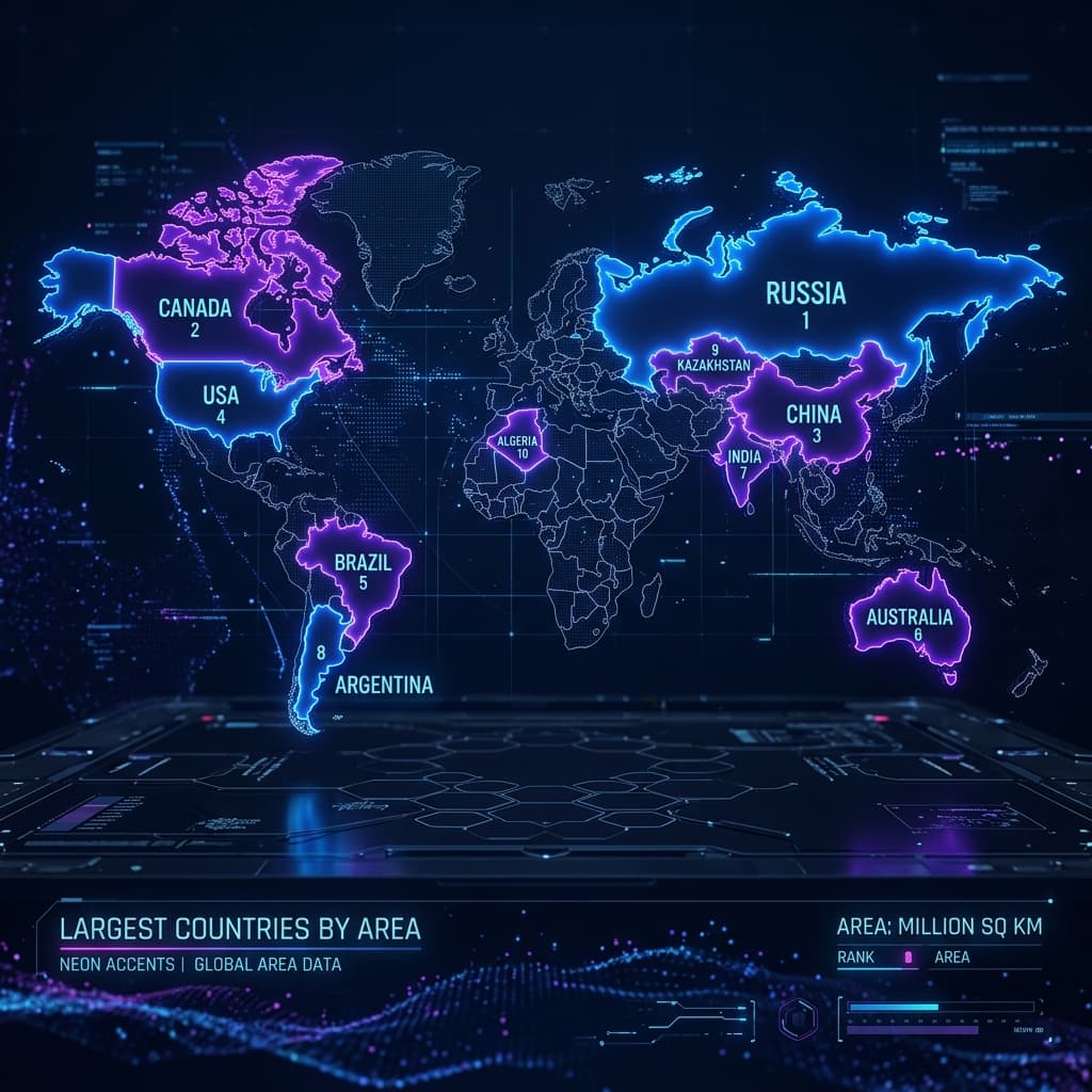
The largest country in the world is Russia, covering 17.1 million square kilometers — roughly 11.5% of all land on Earth. It spans 11 time zones and is bigger than the surface area of Pluto.
But Russia is just the beginning. The top 10 largest countries alone cover approximately 57% of all land on Earth. That means fewer than 5% of the world's 195 countries hold more than half of all habitable land.
What makes this list truly fascinating is the contrast between size and population. Russia is the biggest country but ranks only 9th in population. India is only 7th by area but has the most people of any country on Earth. And Bangladesh, which is smaller than the US state of Iowa, has more people than Russia.
At World Guesser, our team builds geography games that cover every country on this list — from the vast steppes of Mongolia to the dense cities of India. That experience shaped this guide.
The 20 Largest Countries in the World (Ranked by Total Area)
Here is the complete ranked list of the 20 biggest countries on Earth, including total area, estimated population, density, continent, and a key fact for each.
| Rank | Country | Area (km²) | Population | Density (/km²) | Continent | Surprising Fact |
|---|---|---|---|---|---|---|
| 1 | Russia | 17,098,242 | 144M | 8.4 | Europe/Asia | Bigger than the surface area of Pluto (17.6M km²) |
| 2 | Canada | 9,984,670 | 40M | 4.0 | N. America | Contains ~60% of all natural lakes on Earth |
| 3 | United States | 9,833,517 | 340M | 34.6 | N. America | 3rd largest by total area; 4th by land area only |
| 4 | China | 9,596,961 | 1.42B | 148.0 | Asia | Borders 14 countries — tied with Russia for most |
| 5 | Brazil | 8,515,770 | 215M | 25.2 | S. America | Contains 60% of the Amazon rainforest |
| 6 | Australia | 7,692,024 | 26M | 3.4 | Oceania | ~80% of the land is classified as arid or semi-arid |
| 7 | India | 3,287,263 | 1.45B | 441 | Asia | 7th by area, 1st by population — most people on Earth |
| 8 | Argentina | 2,780,400 | 46M | 16.5 | S. America | Stretches from subtropical jungle to sub-Antarctic ice |
| 9 | Kazakhstan | 2,724,900 | 20M | 7.3 | Asia | Largest landlocked country in the world |
| 10 | Algeria | 2,381,741 | 46M | 19.3 | Africa | Largest country in Africa; 80% is Sahara Desert |
| 11 | DR Congo | 2,344,858 | 105M | 44.8 | Africa | Roughly the size of Western Europe combined |
| 12 | Saudi Arabia | 2,149,690 | 37M | 17.2 | Asia | No permanent rivers anywhere in the country |
| 13 | Mexico | 1,964,375 | 130M | 66.2 | N. America | 3rd largest country in Latin America |
| 14 | Indonesia | 1,904,569 | 280M | 147 | Asia | World's largest archipelago — over 17,000 islands |
| 15 | Sudan | 1,886,068 | 48M | 25.4 | Africa | Was Africa's largest until South Sudan split in 2011 |
| 16 | Libya | 1,759,540 | 7M | 4.0 | Africa | 4th largest in Africa with only 7 million people |
| 17 | Iran | 1,648,195 | 89M | 54 | Asia | Slightly larger than the US state of Alaska |
| 18 | Mongolia | 1,564,116 | 3.4M | 2.2 | Asia | Least densely populated sovereign country on Earth |
| 19 | Peru | 1,285,216 | 34M | 26.4 | S. America | Contains Amazon rainforest, Andes mountains, and coastal desert |
| 20 | Chad | 1,284,000 | 18M | 14 | Africa | Named after Lake Chad, which has shrunk 90% since the 1960s |
Is the United States actually bigger than China?
This depends on how you measure. By total area (land plus inland water), the US ranks 3rd at 9,833,517 km² and China ranks 4th at 9,596,961 km². By land area only, China is slightly larger at 9,388,211 km² compared to the US at 9,147,593 km².
The difference comes down to water. The US has far more inland lakes and rivers than China, especially in the Great Lakes region. When you include that water, the US edges ahead. When you exclude it, China takes the lead.
Most international sources — including the CIA World Factbook and the United Nations — list the US as 3rd by total area.
Why Maps Lie About Country Size
If you have ever looked at a standard world map and thought Greenland looks about the same size as Africa, you have been tricked by the Mercator projection.
The Mercator map was created in 1569 for navigation. But it stretches countries near the poles to look much bigger than they actually are, while compressing countries near the equator.
Africa (30.4M km²) looks the same size as Greenland (2.17M km²) on maps. In reality, Africa is 14 times larger.
Alaska looks the same size as Brazil. Brazil is actually 5 times larger than Alaska.
Russia appears twice the size of Africa. In reality, Africa is 1.8 times larger than Russia.
Why does Africa look the same size as Greenland on maps?
The Mercator projection exaggerates size in proportion to distance from the equator. Greenland sits at high northern latitudes where the map stretches area by roughly 14 times. Africa straddles the equator where distortion is minimal.
This is not just a trivia curiosity. The African Union backed a "Correct The Map" campaign in 2025-2026, arguing that the Mercator projection contributes to a distorted perception of Africa.
Countries That Are Way Bigger Than You Think
Several countries consistently surprise people with their actual size, due to map distortion and limited media focus:
Algeria
Algeria became the largest country in Africa in 2011. It is bigger than the combined area of France, Germany, Spain, Italy, the UK, Portugal, and the Netherlands. About 80% of the country is Sahara Desert, causing the population to cluster along the coast.
DR Congo
DR Congo is roughly the size of all of Western Europe. Sitting on the equator, it is heavily compressed on standard maps. In reality, it is the 11th largest country in the world.
Saudi Arabia
Saudi Arabia is bigger than Mexico, Indonesia, and France combined. Despite its huge size, it contains no permanent rivers anywhere within its boundaries.
Mongolia
Mongolia is twice the size of Texas but has only 3.4 million people. It is the least densely populated sovereign country on Earth, with about 2 people per square kilometer.
Why is Kazakhstan so big but nobody ever talks about it?
Kazakhstan is the 9th largest country in the world — bigger than all of Western Europe combined, and the world's largest landlocked country. It is rarely discussed because of its geography in Central Asia, its low population (~20 million), and its relative youth on the world stage (independent since 1991).
Countries That Are Surprisingly Small
On the other end of the spectrum, several countries punch far above their weight in global influence despite being physically tiny:
| Country | Area (km²) | Area Comparison | Why It Surprises People |
|---|---|---|---|
| United Kingdom | 243,610 | Smaller than Oregon | Once controlled 25% of Earth's land area |
| Japan | 377,975 | Smaller than California | 4th largest economy in the world |
| Germany | 357,022 | Smaller than Montana | Largest economy in Europe |
| South Korea | 100,210 | Smaller than Iceland | 52 million people vs Iceland's 390K |
| Italy | 301,340 | About the size of Arizona | 8th largest economy globally |
| Switzerland | 41,285 | Smaller than Denmark | One of the wealthiest countries per capita |
The UK is a striking example. At its peak, the British Empire controlled roughly 25% of the world's land area. Today, the UK covers just 243,610 km², making it smaller than Oregon.
Area vs Population: When Size Does Not Match People
One of the most fascinating things about geography is how poorly a country's area predicts its population. Some of the biggest countries are nearly empty, while some of the smallest are packed with people:
| Country | Area Rank | Area (km²) | Population | Density (/km²) | The Contrast |
|---|---|---|---|---|---|
| Russia | #1 | 17,098,242 | 144M | 8.4 | Largest country, 9th by population — mostly empty tundra and forest |
| Canada | #2 | 9,984,670 | 40M | 4.0 | 2nd largest, 90% of population lives within 200 km of the US border |
| Australia | #6 | 7,692,024 | 26M | 3.4 | 6th largest, ~80% uninhabitable outback — most people live on the coast |
| India | #7 | 3,287,263 | 1.45B | 441 | Only 7th by area, but most populous country on Earth since 2023 |
| Bangladesh | #92 | 148,460 | 170M | 1,157 | Smaller than Iowa, more people than Russia |
| Mongolia | #18 | 1,564,116 | 3.4M | 2.2 | 18th by area, but fewer people than Los Angeles |
How can Bangladesh have more people than Russia when Russia is 116 times larger?
Bangladesh covers just 148,460 km² (roughly the size of Iowa) but has 170 million people. Russia covers 17.1 million km² but has 144 million. Bangladesh sits in the fertile Ganges-Brahmaputra delta where flat terrain and abundant water support dense settlement. Russia has vast stretches of frozen tundra, taiga forest, and arid steppe that are essentially uninhabitable.
Why is Canada so huge but has fewer people than California?
Canada is the 2nd largest country in the world, but its population of 40 million is smaller than California's 39 million. Most of Canada's northern territory is Arctic or sub-Arctic with permafrost and limited growing seasons. As a result, 90% of Canada's population lives within 200 kilometers of the US border.
Biggest Country on Each Continent
Every continent has one country that dominates the land area:
| Continent | Largest Country | Area (km²) | How Dominant |
|---|---|---|---|
| Europe/Asia | Russia | 17,098,242 | Bigger than the next 6 European countries combined |
| North America | Canada | 9,984,670 | Slightly larger than the US |
| South America | Brazil | 8,515,770 | Covers nearly half the continent's total area |
| Africa | Algeria | 2,381,741 | Became #1 after Sudan split in 2011 |
| Oceania | Australia | 7,692,024 | Makes up ~86% of Oceania's total land area |
| Antarctica | No countries | — | 7 countries claim territory, none recognized as sovereign |
For more on how countries are distributed, see our guides on how many countries are in Europe and how many countries are in Africa.
Countries That Changed Size in Recent History
Country borders are not permanent. Several nations have gained or lost significant territory in the past few decades:
Sudan was the largest country in Africa until 2011, when South Sudan voted for independence and split off, reducing Sudan's area by 25%.
Ethiopia had a coastline along the Red Sea until 1993, when Eritrea gained independence and made Ethiopia landlocked overnight.
The Soviet Union covered 22.4 million km² until it dissolved in 1991, splitting into 15 independent countries. Russia retained about 76% of the territory.
Serbia effectively lost Kosovo in 2008 when Kosovo declared independence, though Serbia continues to dispute the separation.
For the full story of how the number of countries has changed over time, see our guide on how many countries are in the world.
Can You Find the 20 Largest Countries on a Map?
You now know the 20 biggest countries on Earth, their areas, populations, and the surprising facts behind each one. But how many of them can you actually find on a map?
At World Guesser, we test your ability to recognize countries from real-world photos — not distorted flat maps.
Location photos from countries of every size. Tell Russia from Canada or Brazil from Argentina.
A new geography puzzle every day. Same locations for all players.
Can you identify the flags of the 20 largest countries? See our guide to hardest flags.
Know the capitals of all 195 countries, including every country on this list.
Studies show that playing geography games regularly improves memory and spatial awareness.
Frequently Asked Questions
What is the largest country in the world?
Russia is the largest country in the world by total area, covering 17,098,242 square kilometers. It spans 11 time zones, stretching from the Baltic Sea in the west to the Pacific Ocean in the east. Russia's total area is nearly twice that of Canada, the second largest country.
What are the top 5 biggest countries by area?
The five largest countries by total area are Russia (17.1M km²), Canada (10.0M km²), the United States (9.8M km²), China (9.6M km²), and Brazil (8.5M km²). Together, these five countries cover approximately 39% of all land on Earth.
Is the US bigger than China?
By total area (land plus water), yes — the US is slightly larger at 9,833,517 km² compared to China's 9,596,961 km². By land area only, China is slightly larger. The difference depends on whether inland water bodies like the Great Lakes are included in the measurement.
What is the smallest country in the world?
Vatican City is the smallest country in the world at just 0.44 square kilometers. It is located inside Rome, Italy, and has a population of approximately 800 people. The second smallest is Monaco at 2.02 km².
What is the least densely populated country?
Mongolia is the least densely populated sovereign country, with approximately 2.2 people per square kilometer. If you count territories, Greenland (an autonomous territory of Denmark) has an even lower density at about 0.14 people per km².
Why does Russia look even bigger on maps than it actually is?
Standard world maps use the Mercator projection, which stretches areas near the poles. Since Russia is at a high northern latitude, it appears significantly larger than its true proportional size relative to equatorial countries. On a Mercator map, Russia looks about twice the size of Africa — but in reality, Africa is 1.8 times larger.
Which continent has the largest countries?
Asia and the Americas contain most of the world's largest countries. Russia (Europe/Asia), China, India, Kazakhstan, and Saudi Arabia are all in or partially in Asia. Canada, the US, and Mexico are in North America. Brazil, Argentina, and Peru are in South America.
Has any country recently changed in size?
Yes. Sudan lost roughly 25% of its territory when South Sudan became independent in 2011. Ethiopia lost its entire Red Sea coastline when Eritrea became independent in 1993. And the Soviet Union dissolved into 15 countries in 1991, with Russia retaining about 76% of the former territory.
This article was written and fact-checked by the World Guesser editorial team. Area data sourced from the CIA World Factbook. Population figures are 2026 estimates from the United Nations. Last updated: July 2026.
Think you can find all 20 on a map? Play World Guesser free and prove it.